I’ve backed down from hiking up Tryfan with my kids SO many times, I can’t count. There are various reasons, mostly to do with incoming fog or rain clouds and my fear of getting lost / crag-fast / falling off something scary and dangerous near the top. Also we swim at Llyn Bochlwyd a LOT, and then finding that at about 3pm, there’s a window to nip up to the summit, but ohhhh… clouds on the horizon, sort of tired legs, hmmmm, nah.
This week we had a forecast of bright, unrelenting sunshine with not a single cloud, let alone fog, from Monday to Friday.
[checks map, yup, we ARE in Wales, this IS happening]
[Yup, really]
Tryfan — 3 peaks — looks like a stegosaurus — 917m and 4 miles
OK, Tryfan looks like a monster and it acts like one. Every year, people are air-lifted off it and it claims lives (see Ogwen rescue page for Tryfan’s regular mentions — from 1-10 Aug 2022, MR received 7 calls from Tryfan). It’s not huge — 917m, and 3-4 miles up and down — but it’s also not an easy walk, or even a walk — it’s a scramble.
If in doubt, don’t go. Either way, read Mud and Routes.
Tryfan north peak
Here’s my unasked-for advice: navigate!
My personal two biggest problems with Tryfan are the steep drops and finding my way down. All routes lead to the top, so getting up is straightforward nav: walk till the path runs out, then scramble till there’s nowhere higher, ta-daa, top.
However, AT the top, there are 360 degrees of rubble and damn-all clues as to the way down, and about 355 of those degrees lead to somewhere dangerous — crags and cliffs that will see hikers either falling hard or clinging to something and stuck. Once you’ve made it up, you’re going to spin around looking at the epic views, and then suddenly the path down could be one of two ways, or three, or four…
Phone maps, OS online, are brilliant in many places but here, reception is patchy. This affects map data AND rescue calls, so sure, take a phone and use OS online, but paper maps + compass are essential — weatherproof ones; map covers with string are good. Plot a course in advance and don’t deviate by an inch. Be good at it.
Note also that if you have dodgy phone reception, the marker arrow on OS online maps can have a lag and place you a few feet behind where you actually are. This MATTERS. Wiggle and calibrate regularly.
I’m scared of Tryfan. It commands respect.
Routes up
There are lots of routes up Tryfan — again see Mud and Routes. We chose the
Llyn Bochlwyd/Bwlch Tryfan south path
because it’s the easiest, and also gorgeous.

It was hot, and Youngest and I were still recovering from COVID (persistent coughing weeks after the infection, headaches, nosebleeds) so we needed an easy hike. We chose to go up to Llyn Bochlwyd for a swim and then trek south to Bwlch Tryfan, then north on a nice little hiking path to the point just below the first peak on the north side (just past Tryfan South peak), where it turns into a scramble.
Is the path easy to find?
To Bwlch Tryfan it’s very straightforward and marked up on the map, and then there’s also a fairly clear path north to Tryfan south peak. After that, it becomes more bouldery.
It can be a nice idea to try out the lower reaches before going to the top — knowing half the route well makes the overall ascent MUCH easier. Lovely walks using this path are
- Hike from Ogwen to Llyn Bochlwyd for a swim
- Hike to Tryfan’s Far South Peak (smaller, easier, nice little area for a snack/picnic)
- Hike over Bwlch Tryfan to the southeast along the goat path to Llyn Caseg-Fraith (and on to Y Foel Goch — on our list to visit) or Glyder Fach.
Our day

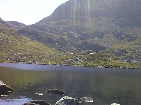
We walked from the A5 to Ogwen car park (for chocolates and toilets — also there are drinks and ice creams here, it’s a good pitstop), and then ambled over the relaxing stepping stone path to Bochlwyd waterfall, and up the steep little path beside it, to the north shore of Llyn Bochlwyd. This is all straightforward, clearly marked, and although the waterfall path is steep, it is passable as a walk. At the top, it opens out into a field of boulders and the path isn’t clear. It’s easy to find the lake and navigate from there up to Bwlch Tryfan but the top of the path isn’t marked or particularly visible so if you aren’t very familiar with it, take a quick bearing and make a note of where the top of the path is, for when you go back down.
Llyn Bochlwyd is one of my favourite swims. I sometimes say Glaslyn’s my favourite, but honestly, Bochlwyd stole my heart over and over. It’s where I go when I’m tried, stressed, or sad — I slide in and it heals me. It’s beautiful — a smooth, easy, lazy lake nestled between Tryfan and Glyder Fach, reflecting the sky, almost but not quite an infinity pool (the north shore has a line of rocks between lake and sky, but the view is breathtaking). If you get here and decide not to go any further, you’ve still had a really lovely day out and there are few better places for a picnic, watching the fish jump, and an afternoon snooze in the sun (or peeing rain, whichever).
We keep meaning to go up the mountains FIRST and then swim on the way home to cool off, but every time Bochlwyd lures us in on the way up — we can’t resist — and that works just fine, too.
(N.b. slide in, don’t jump — there are a lot of rocks just under the surface by the shore, waiting for your elbows and shins. As soon as you’re past this, it’s good swimming.)
So we swam, lazed around on our backs, stared at the cloudless sky, and ate fig rolls and Eccles cakes on the shore.
Then, Tryfan.
We stomped up the clearly visible path on the east shore of Llyn Bochlwyd, heading south-east to Bwlch Tryfan. Just before the stile at the end, the path veers left (east), and curves around to head north to Tryfan South peak, then flanks it heading up towards the North peak. There are a couple of easy scrambles and then just south of the main peak, it becomes a proper scramble.
Tryfan north peaks has two peaks, kind of. The main north peak is the northern one, but there’s an intermediate sub-peak/shoulder beforehand. For us, on this hot day, this threw us a nosebleed challenge. My youngest child’s nose, as it had throughout covid a few weeks before, exploded. So we made it “almost” to Tryfan north peak, but the nose meant we decided to stop, sit, enjoy the view, and relax a moment.
The nose didn’t relent. We were tired and aching, aware of lost fitness during the Covid weeks, and I will never be someone who pushes children up hills — so we stopped. My elder children, meanwhile, wanted to see the summit, so they went on without us. Yup, I sent two of my children to the top of Tryfan without me.
Really?!
Perhaps this was my biggest mountain of the day: not the rocks beneath me, but realising that my baby — my little, blond, trusting, vulnerable child — is in fact now a six foot one adult. His brother, five foot nine, is not far behind. They’ve been this far several times, they’ve both navigated DofE hikes without me, they’re fitter, stronger, and more agile than me. They read maps, and have phones. They’re not stupid; they’re cautious. They were less than 200m from the summit on a perfectly clear day. More importantly, if I said no, they’d probably come up with friends instead — but they’d never get a day this clear again — not one single cloud.
I sat with my younger child as they vanished over the rocks ahead.
And sat. And sat.
And hauled my youngest up an extra 10m to get clear phone reception. I lasted about 15 minutes before I phoned: they were fine, scrambling.
And then they were back, “Muuum!”
They had, as promised, refrained from jumping between Adam and Eve, and they had stood still while taking photos.
We walked back down easily, stopping by at South peak on the way, to give Youngest a summit too.
On the way down, we were overtaken by a family with about five children. The adults were wearing Crocs, not even with the strap around the back. When the Crocs fell off, they just put them back on again. The children, maybe 7 to 13 years old, all in plimsolls, were skittering about, in and out of sight, clambering everywhere. They were fearless. They swarmed up to the summit, and kept in touch by shrieking from the north summit to the bwlch to the south peak, hollering at one another, echoing. Stumbling along behind, a grandfather approached, asked whether we had seen his children go up, and where the summit was? How long would they be, and when could he expect them to return? None of them had packs, no water, no first aid kits. No one was clutching paper maps and the children carried nothing. They navigated by asking the other hikers which way to go. They pretty much ran the whole thing. They were all fine and had a lovely day, and once again I wondered whether I was too cautious, or not cautious enough, or where’s the balance in this crazy, high, beautiful, sometimes-deadly place? And the answer is, I don’t know.
I am cautious when I go up. That feels right to me, and it’s what I recommend.
Tryfan is a fun scramble if you like heights and if it’s a beautiful day. It’s stunning but because there’s been so much sadness on the mountain, it’s not my favourite. It’s something my kids wanted to do, and they’ve done it.
Now, can we please go back to Llyn Bochlwyd, slip into the water, lie back, and stare at the sky?